


Page 23 - 2000 (5) Agricultur Census 2000 Balochitan Province
P. 23
This census covered whole of                  under roads, rails, ravines, rivers,
        the country, i.e. NWFP (including                    canals, Government forests, parks,
        Provincially  and                    Federally       lakes, shallow lands, hills and
        Administered  Tribal Areas / Agencies),              mountains, etc. falling under the
        Punjab (including lslamabad district),               category of non-farm area is outside
        Sindh and Balochistan provinces. The                 the gcope of the census. The chart
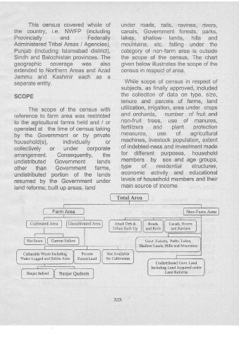
        geographic coverage was also                         given below illustrates the scope of the
        extended  to Northern Areas and Azad                 census in respect of area.
        Jammu and Kashmir each as a
                                                               While scope of census in respect of
        separate entity.
                                                             subjects, as finally approved, included
        SCOPE                                                the collection of data on type, size,
                                                             tenure and parcels of farms, land
               The scope of the census with                  utilization, irrigation, area under crops
        reference to farrn area was restricted               and orchards, number of fruit and
        to the agricultural farms held and / or              non-fruit trees, Lise of  manures,
        operated at the time of census taking                fertilizers and  plant protection
        by the Government or by private                      measures, use  of  agricultural

        household(s), individuaily  or                       machines, livestock population, extent
        collectively or  under corporate                     of indebted-ness  and investment made
        arrangement. Consequently,  the                      for different purposes,  household
        undistributed Government lands                       members by sex and age groups,
        other than Government  farms,                        type of  residential structures,
                                                             economic activity and educational
        undistributed  portion of the iands
                                                             levels of household  members anci their
        resumed by the Government  under
        land reforms; bullt up areas, land                   main source of income.


                Cultivated Area    Uncultivated  Area     Abadi Deh &
                                                         Urban Built Up


                                                                         Govt. Fotests,  Parks, Lakes,  .
                                                                      Shallow Lands, Hiils and Mountains
             Culhuable lYaste Inciuding   Private     Not Availabie
           Water-I-ogged  and Saliqe Arla  Forest l-and  for Cultivation
                                                                               Undistributed  Govt. Land
                                                                            Including  Land Acquired under
                                                                                   Land Reforrns


                                                          XIX

